Actual poster size 27 in. wide x 10 in. high
A poster of this map is AVAILABLE!!!
The Route Across Europe Map, taken from The History of The 272nd Infantry Regiment, may still be obtained so your family and friends can follow the 69th's march across Europe during WWII. Map(s) will be sent in a mailing tube to avoid folds or creases.
One map is a donation of $10.00. Each additional map is a donation of $5.00 each.
Order maps for yourself, children and grandchildren to frame for display.
Send your order information and Unit, with your and payment check or money order to:
Joe Lipsius
69th Infantry Website
6314 Deerings Hollow
Norcross, GA 30092-1800
(770) 416-7725
annejoelip@bellsouth.net
Allows 10 days for delivery. (770) 416-7725
History of this unique piece of history:
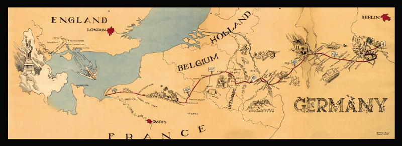
At the close of WWII, the 272nd Infantry Regiment printed a history of its movement from the time it left Camp Shelby, MS until the war in Europe ended VE-Day. Among the outstanding features of the history was a four page, fold-out color map drawn by Werner C Abken and Roland L. Smith of Company C and Service Company of the regiment. The size of the map extended was about 27 inches by 10 inches.
The map shows the route movement of the 272nd Infantry Regiment from the time it left New York until it reached Torgau, April 26,1945, where it performed its mission of guarding the road area between Eilenburg and Torgau, Germany But it is generally the route taken by the entire 69th Infantry Division and its Attached Units in WWII.
When ordering, please include the following information:
Your full name
Your mailing address
Your 69th or attached unit (or that of your loved one or friend, if you know it)
Your email
Your telephone
Number of maps you want
(Allow two weeks for delivery)
![]()
Site support by Leader Technologies® — provider of Leader Phone® audio conferencing and teleconferencing services.